
- Dr. Alonso Arellano, academic at the Department of Metallurgical Engineering, conducts a Dicyt research which seeks patterns that allow the projection of a possible earthquake or volcanic eruption of great magnitude, through the analysis of high-resolution satellite images.
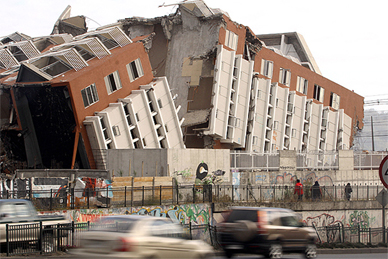
Predicting an earthquake is one of the highest aspirations of the researchers in this field worldwide. In a country like Chile, which is considered highly seismic, this search has become an essential need. In this context, a new process for early detection of earthquakes arises: the analysis of high resolution satellite images.
Dr. Alonso Arellano conducts a project funded by the Department of Scientific and Technological Research (Dicyt) in this field of research. He felt motivated in 2004 while he was doing a Ph.D. at the State University of Russia and subsequently investigated related phenomena, such as the case of the Popocatepetl volcano, located in the south of Mexico.
Through his project, called "Use of high-resolution satellite images for the study of strong earthquakes and related phenomena", additional information is sought to identify more patterns and better statistics.
Based on this information, associated phenomena could be addressed, through the analysis of high resolution satellite images for earthquake precursors. "To achieve this, images are analyzed before, during and after the earthquake. Then, each image is scanned in order to find typical structures, veins, fractures, faults, and thus confirm existing or new patterns,” Arellano said.
According to this researcher, the study is based, on the assumption that the stress of the Earth’s crust can be seen in the form of lines. "The lines are visible when processing high resolution images captured by satellites, although they develop over 30 kilometers deep. For this reason, these images have become an important tool to detect areas of potential earthquakes,” he remarks.
Although in the last decade many similar investigations have been carried out by the international group led by Dr. Arellano in Chile, and by Dr. Dimitar Ouzounov in the United States, this study will differ in two aspects: first, the use of the Chilean satellite FASAT Charlie, if the agreement with the Air Force, through the Aerophotogrametric Service, becomes effective. The second aspect is the use of software for the study of images, developed at the University of Santiago, Adelgeo.
Dr. Arellano’s collaborators are Ph.D. students in Engineering Science (Automatic and Process specializations) and the Master’s degree in Geomatics. As noted by professor Arellano, "they play an important role, because their motivation to do new things nourishes the investigation."
By Lorena Jimenez